
Mapping Racial Covenants
Documenting the extent of exclusion in Northern Virginia–in Arlington and Fairfax Counties as well as Falls Church and Alexandria Cities–via web maps enables us to broaden our understanding of the “choices” made regarding where people lived in the past. During this process, we confront a common assumption: that segregated neighborhoods evolved out of a series of individual decisions that led to the creation of homogeneous neighborhoods. By locating the extent to which private action limited housing options for African Americans and others, we hope to help shed light on the systemic versus individual nature of these exclusionary practices across NoVA during the periodization of 1900-1968. These maps underscore the importance of thinking about the local history of housing segregation BOTH systemically AND regionally.
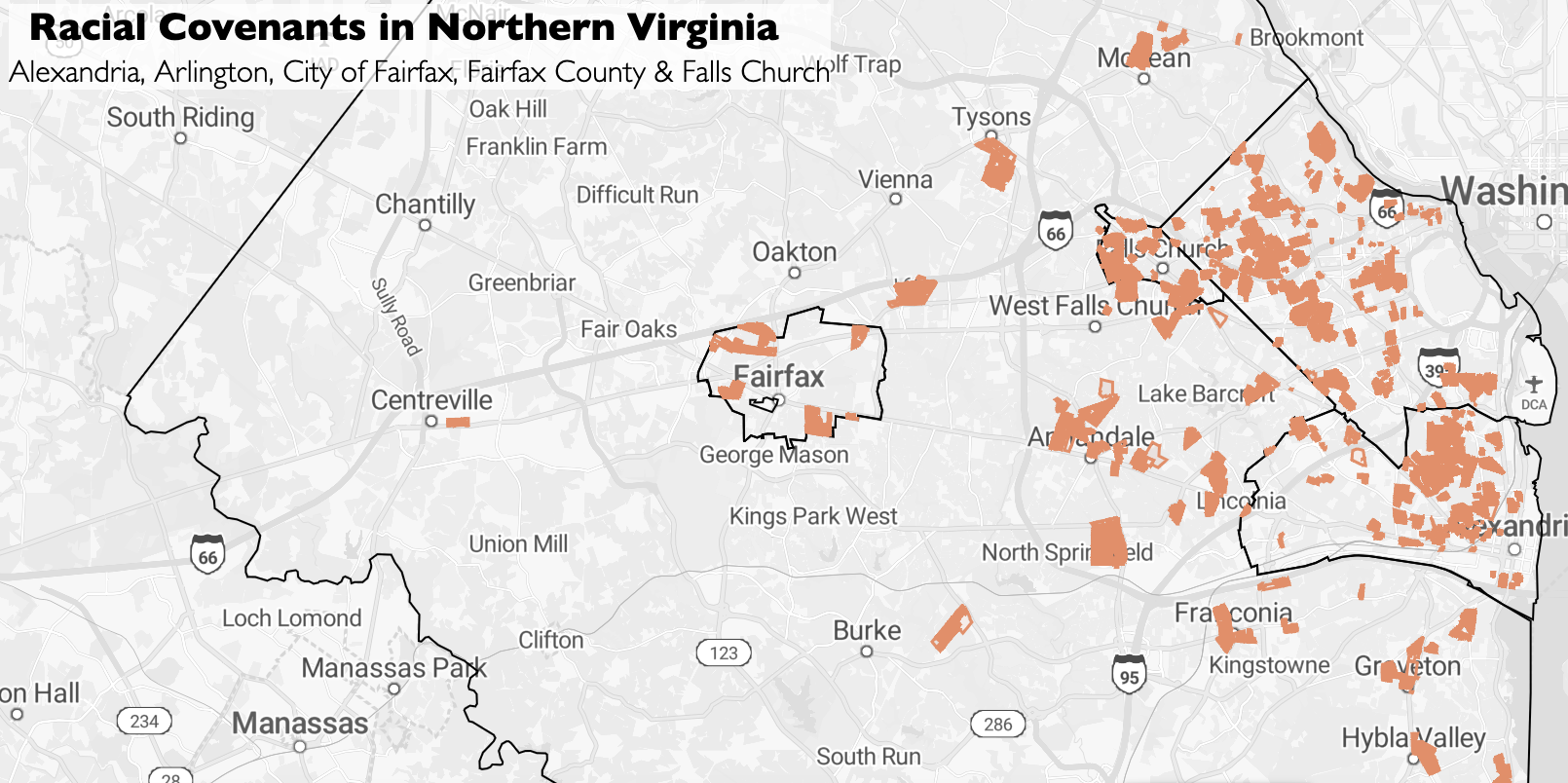
Visualizing Exclusion
We constructed a map by locating residential parcels for which we found a racially restrictive covenant in public land records from 1900 to 1968. Click on an orange shaded lot to access a pop-up that lists the: covenant document recording date, covenant language, and subdivision or estate of the associated covenant.
Map Shading
Each orange shaded lot has a racial covenant that has been verified. In some cases where multiple covenants are associated with a lot, it appears in a darker shade.
Covenant Language on Map
The covenant language appearing on this map may not replicate all minor non-substantive variations such as punctuation, capitalization, spelling errors, or spacing that appear in the racial covenant text of the deed or deeds associated with a given parcel.
Reading the maps
- Racial Covenant: The term racial covenant and racially restricted covenant are used interchangeably on this website.
More on racial covenants.
- Land Record: “Land records document” means any writing authorized by law to be recorded and submitted to a local courthouse.
- Lots & Parcels: Unless otherwise specified, these terms are used interchangeably on this website to refer to a piece(s) of property.
- Subdivisions & Estates: The subdivisions and estates we list were drawn from the legal descriptions used in the land records of each jurisdiction. The descriptions may differ from contemporary references to neighborhoods such as those used colloquially or by citizen, civic, or community associations. Our usage recognizes the historical changes to the definition of and associated policies regarding the term “subdivision” that occur under VA law and local ordinances.
To access the NoVA regional interactive map that displays the racial covenants located to date, click on the button above. While the navigation specifics may differ depending on the configuration of a specific user’s system, it is possible to move around the map:
- Zoom in using the [+] key to see additional details, including neighborhoods, street names, etc.
- Zoom out using the [-] key to explore the regional distribution of covenants.
Future Work…
The goal of Documenting Exclusion is to visualize the dynamics of racial restrictions in the past relative to the resilience demonstrated by excluded communities in the NoVA region. After we locate private agreements of exclusion such as racial covenants, we will shift our attention to creating maps that integrate the African American, or “non-Caucasian” resident experience. By doing so we hope to gain a better understanding of the role that the resilience of communities and the actions of those living in these communities played in shaping the local history of residential segregation in NoVA.